
Roads to Nowhereroadsoceantide
This Road Vanishes Underwater Every Day, Beauvoir-sur-Mer
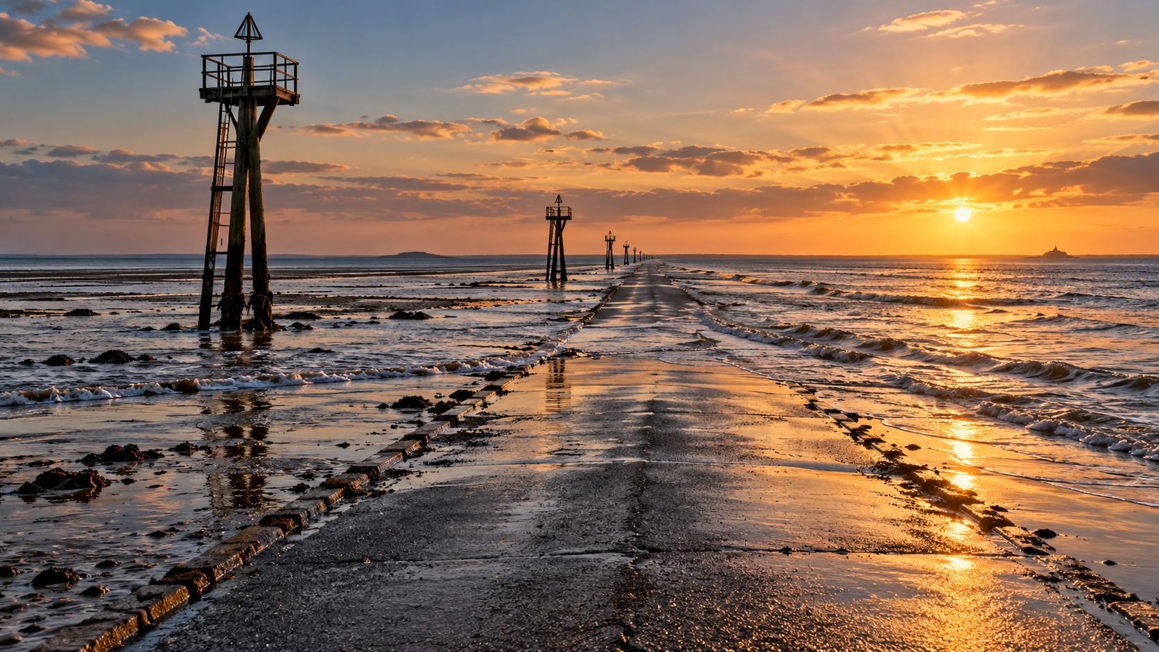
Twice a day, the Passage du Gois in western France vanishes under the Atlantic. The 2.6-mile tidal road to Noirmoutier can only be crossed at low tide.
Every claim sourced
20 claims · 20 sources
0 disagreements logged
0 editorial corrections
Last checked Oct 2, 2026
The story
The numbered claim log below connects facts in this story to their sources.
Twice a day, a road in western France disappears into the sea. The Passage du Gois is a paved causeway about 4.1 kilometers (2.6 miles) long, linking the mainland at Beauvoir-sur-Mer to the island of Noirmoutier. It isn't a bridge or a raised embankment. It's a road laid across a natural sandbank in the Bay of Bourgneuf, and when the tide comes in, the Atlantic covers it. Noirmoutier was once reachable only by boat. Over centuries, the bay silted up, forming a sandbank that people and animals could wade across at low tide. The name is often traced to an old local word, goiser, meaning to walk with your feet in the water. The crossing appears on a map by 1701, and a regular route was established around 1840. The road was later paved and widened into the one drivers use today. The rules are simple and absolute. The road can be crossed for about an hour and a half before low tide and an hour and a half after. For the rest of the time it sits under the sea, as much as about four meters (13 feet) deep at high tide. Signs at both ends post the day's safe window. Parking on the causeway is forbidden. The water comes back fast, and every year some visitors misjudge it. For them, the road has refuge beacons, tall poles with platforms spaced along the causeway, where anyone caught by the rising tide can climb up and wait for rescue or for the water to go out again. Today nine of them line the route. At low tide, the causeway fills with people. Cars park on the sand, and families walk out onto the mudflats with buckets and rakes to dig for clams, cockles and oysters. The Gois has had its moments on a larger stage. In 1999, the Tour de France sent riders across it during the race's second stage. The wet, slippery surface caused a crash that split the peloton by six minutes and cost several favorites the race. The Tour came back in 2011 and used the causeway as the start of the first stage. Every year, runners in the Foulées du Gois race against the incoming tide. Since 1971, a bridge has connected Noirmoutier to the mainland farther south, at Fromentine. The old road across the sand is still used, twice a day, whenever the sea allows it.
Last corrected: no editorial corrections on this page yet.
Grew up near here?
Get the free Beauvoir-sur-Mer guide: every Hidden Current place in the region, with what you can still see and how to get there.
State guides are coming soon. Email signup is not available yet.
Watch the short documentary
This Road Vanishes Underwater Every Day, Beauvoir-sur-Mer
Claim log
| # | Claim | Sources | Status |
|---|---|---|---|
| 1 | The Digue du Gois, Barbâtre, is at WGS84 46.933814, -2.1481112 |
| Sourced |
| 2 | The hike start at Le Gois, Beauvoir-sur-Mer, is at 46.920964, -2.103597 |
| Sourced |
| 3 | The causeway is 4.125 km (2.6 mi) long and floods twice a day |
| Sourced |
| 4 | The causeway is 4.125 km (2.6 mi) long and floods twice a day |
| Sourced |
| 5 | Noirmoutier was once reachable only by boat; the bay silted up and people and animals could wade across |
| Sourced |
| 6 | The name comes from 18th-century goiser, "to get your feet wet while walking in water" |
| Sourced |
| 7 | The crossing was first on a map in 1701, with regular service around 1840 |
| Sourced |
| 8 | The road was paved and widened in the 1930s |
| Sourced |
| 9 | The road can be crossed about 1.5 hours before and after low tide |
| Sourced |
| 10 | There are 1.3 to 4 meters of water at high tide |
| Sourced |
| 11 | Tide signs are posted at both ends |
| Sourced |
| 12 | Parking on the causeway is strictly forbidden |
| Sourced |
| 13 | Many visitors get caught every year; elevated rescue towers line the route |
| Sourced |
| 14 | There are nine refuge beacons today |
| Sourced |
| 15 | There are nine refuge beacons today |
| Sourced |
| 16 | Clams, cockles and oysters are gathered at low tide |
| Sourced |
| 17 | In 1999 Tour de France stage 2, a crash on the slippery surface caused a six-minute split; Alex Zülle finished second overall |
| Sourced |
| 18 | In 1999 Tour de France stage 2, a crash on the slippery surface caused a six-minute split; Alex Zülle finished second overall |
| Sourced |
| 19 | The causeway was the start of stage 1 of the 2011 Tour de France |
| Sourced |
| 20 | The Noirmoutier Bridge from Fromentine has existed since 1971 |
| Sourced |
Disagreements logged
No approved disagreements are logged on this page yet.
Submit a disagreement
Disagree with a fact in this story? Submit a source-backed note for editorial review. It stays private until approved and does not automatically become a correction.
Sources
- French national flood-marker platform
- VisuGPX
- Wikipedia
- Beauvoir-sur-Mer town hall
- Source needs identification
- Travelhoppers
- Amusing Planet
- French Adventure Lab description
- Cycling Weekly
Corrections
No editorial corrections are logged on this page yet.