
Nature Took It BackKolmanskopNamib DesertNamibia
Kolmanskop: The Diamond Town the Namib Desert Is Swallowing
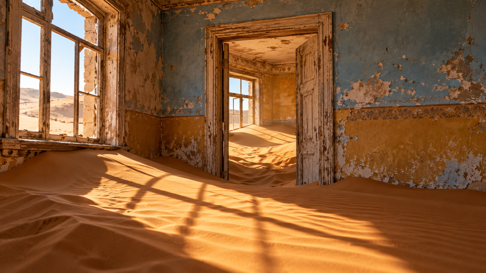
Kolmanskop boomed after a diamond was found in 1908. Abandoned by 1956, its German-style houses now stand deep in the drifting sands of the Namib Desert.
Every claim sourced
26 claims · 26 sources
0 disagreements logged
8 editorial corrections
Last checked Oct 6, 2026
The story
The numbered claim log below connects facts in this story to their sources.
In April 1908, in what was then the German colony of South West Africa, a railway worker named Zacharias Lewala was working on the line near Lüderitz when he picked up a shiny stone. Lewala had worked in the diamond mines of Kimberley before, and he brought the stone to his supervisor, the German railway inspector August Stauch. Stauch reportedly tested it by scratching the glass of his watch. It was a diamond. Stauch and his partner, the mining engineer Söhnke Nissen, quietly quit their jobs and staked claims to about 75 square kilometers of desert. Word got out anyway, and a diamond rush followed. That same year, the colonial government declared the southern coastal strip a restricted diamond area, the Sperrgebiet, which is still restricted today. On a small rise in the dunes, the boomtown of Kolmanskop grew almost overnight. Its name is often traced to a transport driver, Johnny Coleman, who abandoned his ox wagon on an incline opposite the settlement during a sandstorm. Its new residents built a German town in the middle of the desert: solid houses, a school, a ballroom, a theater and sports hall, a casino, a skittle alley, an ice factory and a power station. Its hospital is often said to have had the first X-ray machine in the southern hemisphere. Fresh water was shipped about 1,000 km from Cape Town. A small tram delivered ice and soda water to homes. The boom didn't last. The local diamond field began running down after World War I. In 1928, far richer diamond deposits were discovered about 270 km to the south, on the beach terraces near the Orange River, and the industry moved there. Kolmanskop's residents followed, and the town emptied. By 1956, it was abandoned. The desert started taking it back almost immediately. Sand blew through broken windows and open doorways, piling up in drifts inside the houses, burying floors, climbing walls and filling rooms. The extremely dry climate preserved the buildings' Edwardian-era architecture even as the dunes moved in. In 1980, Kolmanskop's tourism potential was rediscovered. A few buildings were dug out of the sand and restored, and guided tours began. The town has since become one of the most photographed ghost towns in the world, and a filming location for movies such as The King Is Alive. Most of Kolmanskop has been left as the sand found it. Each year, the dunes push a little further into the town.
Last corrected: Oct 6, 2026.
Grew up near here?
Get the free state guide: every Hidden Current place in the region, with what you can still see and how to get there.
State guides are coming soon. Email signup is not available yet.
Watch the short documentary
Kolmanskop: The Diamond Town the Namib Desert Is Swallowing
Claim log
| # | Claim | Sources | Status |
|---|---|---|---|
| 1 | Kolmanskop is at 26°42′15″S 15°13′57″E (26.70406°S 15.232365°E) |
| Sourced |
| 2 | Kolmanskop is at latitude -26.703889, longitude 15.232778 |
| Sourced |
| 3 | Kolmanskop is a ghost town in the Namib in southern Namibia, 10 kilometres inland from Lüderitz |
| Sourced |
| 4 | Kolmanskop is about 15 km east of Lüderitz |
| Sourced |
| 5 | In 1908, railroad worker Zacharias Lewala found a diamond and showed it to his supervisor, German railway inspector August Stauch |
| Sourced |
| 6 | On 10 April 1908, Zacharias Lewala, who had previously worked at a diamond mine in Kimberley, picked up a diamond and brought it to Stauch |
| Sourced |
| 7 | Stauch confirmed his suspicion by scratching his glass watch with the stone |
| Sourced |
| 8 | Zacharias Lewala discovered a diamond on 14 April 1908 |
| Sourced |
| 9 | Stauch and Söhnke Nissen quit their jobs and secured claims of 75 km² at Kolmanskop |
| Sourced |
| 10 | In 1908, the southern coastal strip was declared a Restricted Diamond area |
| Sourced |
| 11 | Kolmanskop is located within the restricted diamond area known as the Sperrgebiet, and tourists need a permit to enter |
| Sourced |
| 12 | The town was named after Johnny Coleman, who abandoned his ox wagon on a small incline opposite the settlement during a sandstorm |
| Sourced |
| 13 | The town had a hospital, ballroom, power station, school, skittle-alley, theatre, sport-hall, casino, ice factory, and the first x-ray-station in the southern hemisphere |
| Sourced |
| 14 | Fresh water was brought by ship about 1,000 km from Cape Town |
| Sourced |
| 15 | A tram provided residents with soda water, lemonade and a block of ice |
| Sourced |
| 16 | The hospital had the first x-ray apparatus in southern Africa |
| Sourced |
| 17 | In 1928, the richest diamond-bearing deposits ever known were discovered on beach terraces 270 km south of Kolmanskop, near the Orange River |
| Sourced |
| 18 | By the end of the 1st World War, the diamond field was near-exhaustion |
| Sourced |
| 19 | The town was ultimately abandoned in 1956 |
| Sourced |
| 20 | The last inhabitant left Kolmanskop between 1956 and 1960 |
| Sourced |
| 21 | Kolmanskop is popular with photographers for the desert sands reclaiming the town, and its arid climate preserves the Edwardian architecture |
| Sourced |
| 22 | In 1980, the town's tourism potential was rediscovered, and some houses were dug out of the sands and restored |
| Sourced |
| 23 | Guided tours in English, German and Afrikaans start at 09:30 and 11:00, Monday to Saturday |
| Sourced |
| 24 | Permits can be bought from Lüderitz Safaris & Tours on Bismarck Street; the photography permit allows sunrise-to-sunset access, otherwise hours are 9am to 1pm |
| Sourced |
| 25 | An adult permit allows entry between 9 am and 1 pm Monday to Saturday, and can be purchased at the gate or in Lüderitz |
| Sourced |
| 26 | The 2000 film The King Is Alive was filmed in Kolmanskop |
| Sourced |
Disagreements logged
No approved disagreements are logged on this page yet.
Submit a disagreement
Disagree with a fact in this story? Submit a source-backed note for editorial review. It stays private until approved and does not automatically become a correction.
Sources
- Wikipedia
- NGA GEOnet Names Server
- info-namibia.com
- 4girlsandaghost.wordpress.com
- latitude.to
- The Namibian
- pruskova.com
- thecuriousjournal.com
Corrections
| # | Correction | Sources |
|---|---|---|
| 1 | Kolmanskop was abandoned in the 1950s, about 70 years ago, not more than a century ago; the diamond rush began in 1908 |
|
| 2 | The diamonds did not simply disappear; the local field declined after World War I, and richer deposits were found 270 km south near the Orange River in 1928 |
|
| 3 | Sources disagree on the year Kolmanskop was fully abandoned, giving 1954, 1956, or between 1956 and 1960 |
|
| 4 | Sources disagree on the year Kolmanskop was fully abandoned, giving 1954, 1956, or between 1956 and 1960 |
|
| 5 | The X-ray claim varies by source: first in the southern hemisphere, first in southern Africa, or one of the first in Africa |
|
| 6 | The X-ray claim varies by source: first in the southern hemisphere, first in southern Africa, or one of the first in Africa |
|
| 7 | Sources disagree on the date of Lewala's discovery, giving 10 April or 14 April 1908 |
|
| 8 | Kolmanskop's latitude is south of the equator and must be entered as a negative number, -26.70406 |
|
More Nature Took It Back places
- Abandoned amusement park outside New Orleans
- Craco Vecchia (old Craco), the "ghost town" of Basilicata
- Mallows Bay: The Ghost Fleet of World War I Ships in the Potomac
- Big Pit: The Welsh Coal Mine Where Ex-Miners Take You 300 Feet Down
- Old Cahawba: Alabama's First Capital Lost to the Woods
- Houtouwan: The Chinese Fishing Village Swallowed by Green