
Places That Shouldn't ExistLake ReschenGraundrowned village
Lake Resia: The Bell Tower of the Village Beneath the Water
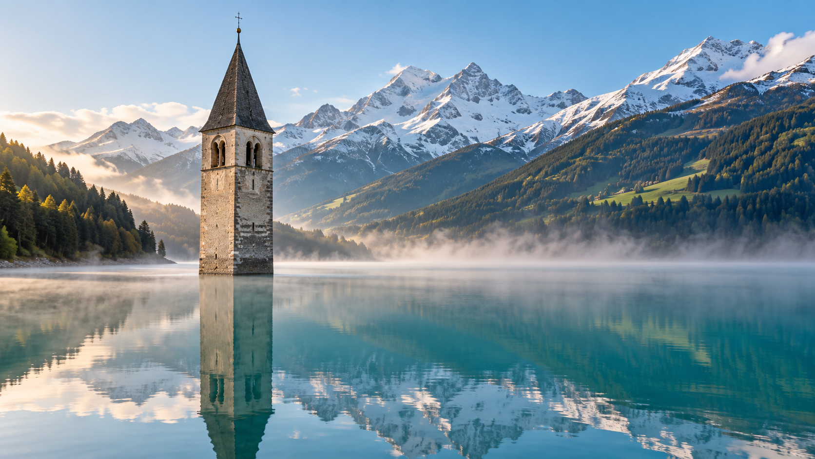
In 1950, a hydroelectric dam flooded the village of Graun in South Tyrol, Italy. Only its 14th-century bell tower still rises from the water of Lake Resia.
Every claim sourced
19 claims · 19 sources
0 disagreements logged
10 editorial corrections
Last checked Oct 6, 2026
The story
The numbered claim log below connects facts in this story to their sources.
High in the Alps of northern Italy, near the borders of Austria and Switzerland, a church bell tower stands in the middle of a lake. There's no church around it and no village, just the stone tower rising out of the blue-green water. The village it belonged to is underneath. The tower was built in the 14th century, part of the Romanesque church of Graun, a farming village in the Vinschgau Valley of South Tyrol. For centuries, Graun sat beside two small natural lakes, the Reschensee and the Mittersee. Plans to turn the area into a reservoir began early. In 1920, there was a proposal for a modest artificial lake about 5 meters deep. Then, around 1939, the Montecatini company announced a much bigger plan: a dam that would merge the two lakes into one lake 22 meters deep, submerging Graun entirely, along with part of the neighboring village of Reschen. The villagers fought it. Construction began in April 1940, but the war and local resistance slowed it down. After the war, the project was pushed forward on the grounds of national interest. The homes of Graun were dynamited, and families were moved out, many into a makeshift camp at the entrance to a nearby valley. Montecatini paid the residents little for their homes. Some moved away for good. Others rebuilt above the waterline, in a new Graun on the hillside, where their descendants still live. The bells were removed from the tower. The church itself was demolished. The tower was left standing. In July 1950, the dam was completed and the water rose. In all, 163 houses and 523 hectares of farmland were submerged. Today the tower is the only part of old Graun still visible, and one of the most photographed sights in South Tyrol. A local legend says that on cold winter nights, you can still hear the bells ringing beneath the lake, even though they were taken down before the flood. In winter, when the lake freezes, people walk out across the ice to stand beside the tower of the village under the lake.
Last corrected: Oct 6, 2026.
Grew up near here?
Get the free state guide: every Hidden Current place in the region, with what you can still see and how to get there.
State guides are coming soon. Email signup is not available yet.
Watch the short documentary
Lake Resia: The Bell Tower of the Village Beneath the Water
Claim log
| # | Claim | Sources | Status |
|---|---|---|---|
| 1 | Reschensee is at 46°48′04″N 10°31′52″E in South Tyrol, near Graun im Vinschgau |
| Sourced |
| 2 | A legend says church bells can still be heard in winter; the bells were removed from the tower on July 18, 1950, a week before the church was demolished |
| Sourced |
| 3 | Plans for a smaller 5 m deep artificial lake date from 1920 |
| Sourced |
| 4 | Montecatini introduced a plan for a 22 m deep lake unifying Reschensee and Mittersee and submerging Graun and part of Reschen |
| Sourced |
| 5 | Dam construction started in April 1940 but, due to the war and local resistance, did not finish until July 1950 |
| Sourced |
| 6 | In total, 163 homes and 523 hectares of cultivated land were submerged |
| Sourced |
| 7 | The bell tower is at approximately 46.8083° N, 10.5414° E, near the village of Curon Venosta |
| Sourced |
| 8 | The bells were removed in July 1949 |
| Sourced |
| 9 | Two of the bells were rehoused in the new church of Curon Venosta on the hillside above the lake |
| Sourced |
| 10 | The tower is 14th-century, and the dam merged two smaller lakes, Lake Resia and Lake Curon |
| Sourced |
| 11 | The Romanesque church of old Curon/Graun was built in the 14th century; the lake is 6 km long |
| Sourced |
| 12 | Residents were dispossessed on grounds of "national interest"; in summer 1950, 163 houses were detonated, and 150 families were housed in a makeshift camp at the entrance to the Langtauferertal Valley |
| Sourced |
| 13 | In 1939, Montecatini announced plans for a 22-meter deep lake; some residents moved away and others rebuilt in upper Graun |
| Sourced |
| 14 | The tower is a few miles from the Swiss and Austrian borders |
| Sourced |
| 15 | In winter, when the water freezes, the tower can be reached on foot |
| Sourced |
| 16 | Montecatini gave families a small amount of money for their homes |
| Sourced |
| 17 | The entire town of Graun, parts of Reschen, and the small villages of Arlung, Piz, Gorf, and Stockerhofe were submerged |
| Sourced |
| 18 | The tower periodically undergoes restoration to protect the masonry from water and freezing temperatures |
| Sourced |
| 19 | The bell tower becomes fully walkable when the lake level is lowered in winter |
| Sourced |
Disagreements logged
No approved disagreements are logged on this page yet.
Submit a disagreement
Disagree with a fact in this story? Submit a source-backed note for editorial review. It stays private until approved and does not automatically become a correction.
Sources
- Wikipedia
- thedarkatlas.com
- sharry.land
- vinschgau.net
- amusingplanet.com
- alluringworld.com
- abandonedspaces.com
- thewomtravel.com
- culturalheritageonline.com
Corrections
| # | Correction | Sources |
|---|---|---|
| 1 | Lake Resia did not flood only Graun; it also submerged part of the village of Reschen and several small hamlets |
|
| 2 | Additional hamlets submerged included Arlung, Piz, Gorf, and Stockerhofe |
|
| 3 | The dam merged two natural lakes, Reschensee and Mittersee, not three lakes as some sources state |
|
| 4 | One source states three lakes were joined by the dam |
|
| 5 | Sources disagree on when the bells were removed: July 18, 1950 |
|
| 6 | Sources disagree on when the bells were removed: July 1949 |
|
| 7 | The flooding destroyed 163 houses; the number of displaced families is given as 150 |
|
| 8 | One source states approximately 163 families were displaced |
|
| 9 | Sources disagree on the bell tower's coordinates by a few hundred meters: 46.8083° N, 10.5414° E |
|
| 10 | Sources disagree on the bell tower's coordinates by a few hundred meters: 46.8108° N, 10.5366° E |
|
More Places That Shouldn't Exist places
- Parícutin: The Volcano That Was Born in a Farmer's Cornfield
- Ferropolis: Germany's City of Iron Built From Giant Mining Machines
- Barra Airport: Where Scheduled Flights Land on a Beach
- Reelfoot Lake: The Tennessee Lake Created by an Earthquake
- Hashima Island: Japan's Abandoned Battleship Island
- Salton Sea: California's Accidental Lake and Its Fading Resorts