
Hidden LandscapesMono Laketufa towersCalifornia history
Mono Lake: The Underwater Towers Los Angeles Left High and Dry, California
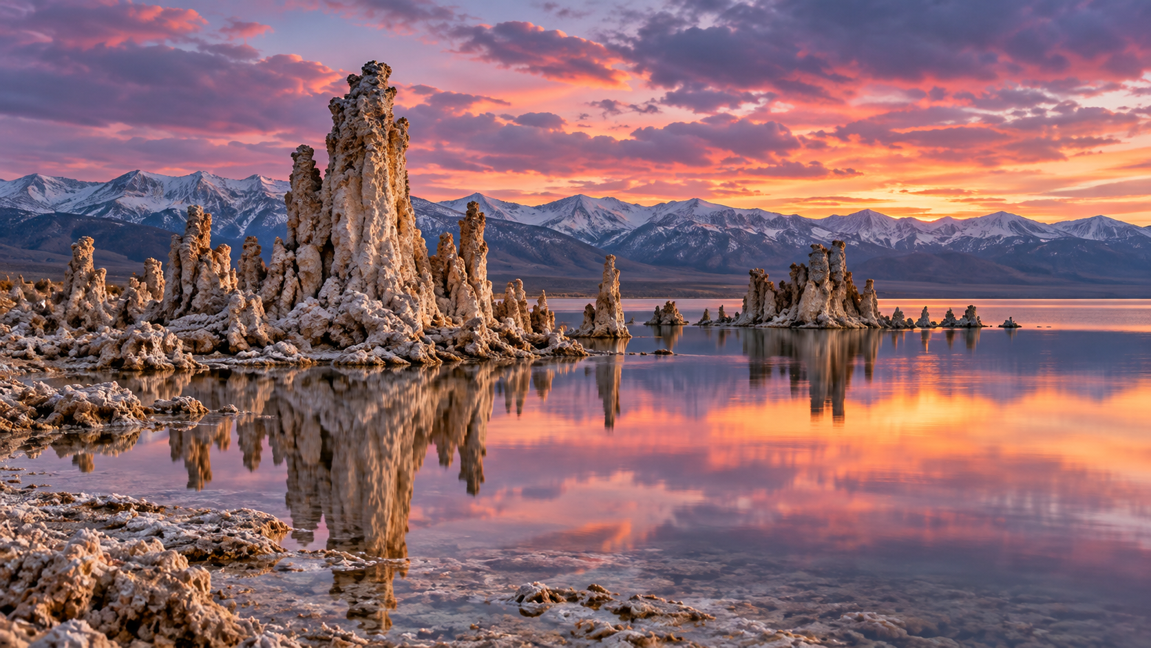
Mono Lake's tufa towers grew underwater where springs met salty lake water. After Los Angeles began diverting its streams in 1941, the lake fell 45 feet.
Every claim sourced
21 claims · 21 sources
0 disagreements logged
5 editorial corrections
Last checked Oct 6, 2026
The story
The numbered claim log below connects facts in this story to their sources.
On the eastern edge of the Sierra Nevada lies Mono Lake, an ancient salt lake with no outlet. Its water is nearly three times saltier than the ocean and highly alkaline. Along its shores stand strange knobby spires and columns of pale stone, some rising more than the height of a two-story house. These are tufa towers. Tufa forms underwater. Beneath the lake, calcium-rich fresh water from springs seeps up through cracks in the lakebed. When it meets the lake's carbonate-rich water, calcium carbonate, or limestone, forms and settles around the spring. Over long periods, it builds up into towers, often lined up along the faults that carry the spring water. As long as they stay submerged, the towers keep growing. For most of their history, the tufa towers along today's shore were hidden underwater. That changed because of Los Angeles, about 350 miles to the south. In 1941, the Los Angeles Department of Water and Power extended its aqueduct into the Mono Basin and began diverting four of the five streams that fed the lake, sending the water south to the growing city. With most of its inflow gone, Mono Lake began to shrink. By 1982, it had dropped 45 vertical feet and lost about half its volume, and its salinity had nearly doubled. The towers that had grown underwater emerged into open air. The falling lake also exposed a land bridge to Negit Island, letting coyotes reach a major California gull nesting colony, and it created dust storms from the exposed lakebed. In 1978, a group of young scientists and activists formed the Mono Lake Committee to save the lake. After a 16-year legal and political fight, in 1994, the California State Water Resources Control Board ordered Los Angeles to cut back its diversions until the lake rose to 6,392 feet above sea level. The lake has risen since, but drought and continued diversions have kept it below that target. Today, the exposed tufa towers have become one of California's most photographed landscapes. If the lake ever reaches its goal, some of them may disappear under the water again.
Last corrected: Oct 6, 2026.
Grew up near here?
Get the free California guide: every Hidden Current place in the region, with what you can still see and how to get there.
State guides are coming soon. Email signup is not available yet.
Watch the short documentary
Mono Lake: The Underwater Towers Los Angeles Left High and Dry, California
Claim log
| # | Claim | Sources | Status |
|---|---|---|---|
| 1 | South Tufa is at 37.940344, -119.028063 and is a day use fee area open 24 hours, 7 days a week |
| Sourced |
| 2 | Mono Lake's water is nearly three times saltier than the ocean, with a pH around 10 |
| Sourced |
| 3 | Drones are not allowed over Mono Lake |
| Sourced |
| 4 | Mono Lake's tufa towers are calcium carbonate rock formations that form underwater; the towers seen today were exposed when LADWP diversions starting in 1941 lowered the lake 45 vertical feet |
| Sourced |
| 5 | Diversions caused Mono Lake to lose half its volume |
| Sourced |
| 6 | In 1994 the State Water Board mandated that LADWP curtail diversions to allow the lake to rise to 6,392 feet |
| Sourced |
| 7 | By 1982, diversions had caused Mono Lake to fall 45 vertical feet, increasing salinity to nearly 100 g/L; at 6,392 feet, salinity will be around 68 g/L |
| Sourced |
| 8 | Diversions exposed a landbridge that enabled coyotes to prey on gull chicks |
| Sourced |
| 9 | Tufa forms when calcium-rich fresh water from springs mixes with carbonate-rich lake water, often in a linear pattern along faults |
| Sourced |
| 10 | Ancient tufa was stranded by the natural recession of a huge ice-age lake; in modern times, diversions exposed more tufa towers |
| Sourced |
| 11 | In 1941, LADWP began diverting water from four of the freshwater streams that feed Mono Lake; between 1941 and the early 1980s, the lake dropped 45 feet, losing half its volume and doubling in salinity |
| Sourced |
| 12 | Visitors should not climb or stand on the tufa towers or take any tufa home |
| Sourced |
| 13 | In 1941, LADWP extended the aqueduct to the Mono Basin to meet the demands of the city 350 miles south |
| Sourced |
| 14 | Drought, evaporation, and continued diversions have stalled the lake's rise to 6,392 feet |
| Sourced |
| 15 | Tufa towers build up over thousands of years; LA diverted four of the five streams feeding Mono Lake |
| Sourced |
| 16 | The South Tufa fee is $3 per adult |
| Sourced |
| 17 | The towers can grow to over 30 feet underwater, building over hundreds of years |
| Sourced |
| 18 | The Mono Lake Committee won a legal battle that forced Los Angeles to partially replenish the lake |
| Sourced |
| 19 | After some 16 years of court battles and hearings, the 1994 decision ordered LADWP to halt withdrawals until the lake climbed 17 vertical feet |
| Sourced |
| 20 | From Highway 395, take Highway 120 east 4.7 miles to Test Station Road, then about 1 mile to the South Tufa parking area |
| Sourced |
| 21 | By 1982 the lake had lost 31 percent of its 1941 surface area |
| Sourced |
Disagreements logged
No approved disagreements are logged on this page yet.
Submit a disagreement
Disagree with a fact in this story? Submit a source-backed note for editorial review. It stays private until approved and does not automatically become a correction.
Sources
- U.S. Forest Service
- Mono Lake Committee
- roadtrippers.com
- americasstateparks.org
- travelingwithmj.com
- Wikipedia
- exploratography.com
- birdandhike.com
- amusingplanet.com
Corrections
| # | Correction | Sources |
|---|---|---|
| 1 | Not all of Mono Lake's tufa was exposed by Los Angeles; ancient tufa was stranded when an ice-age lake receded naturally |
|
| 2 | Tufa growth is described as taking hundreds to thousands of years, not only centuries |
|
| 3 | Sources disagree on how long tufa takes to form: hundreds of years |
|
| 4 | Los Angeles diverted four of the five streams feeding Mono Lake, not all of them |
|
| 5 | Mono Lake has not yet reached the 6,392-foot level mandated in 1994 |
|
More Hidden Landscapes places
- The Desert Hidden Between These Mountains
- Lake Nyos: The Lake That Released a Deadly Cloud in One Night
- Ruby Falls: The Waterfall Hidden Inside Lookout Mountain
- Thor's Well ("the drainpipe of the Pacific")
- Lost Lake, Oregon: The Lake That Drains Into a Hole Every Summer
- Lost River, Indiana: The River That Disappears Underground