
How It Really WorksMississippi Riverengineeringinfrastructure
Old River Control: The Floodgates Holding the Mississippi in Place, Louisiana
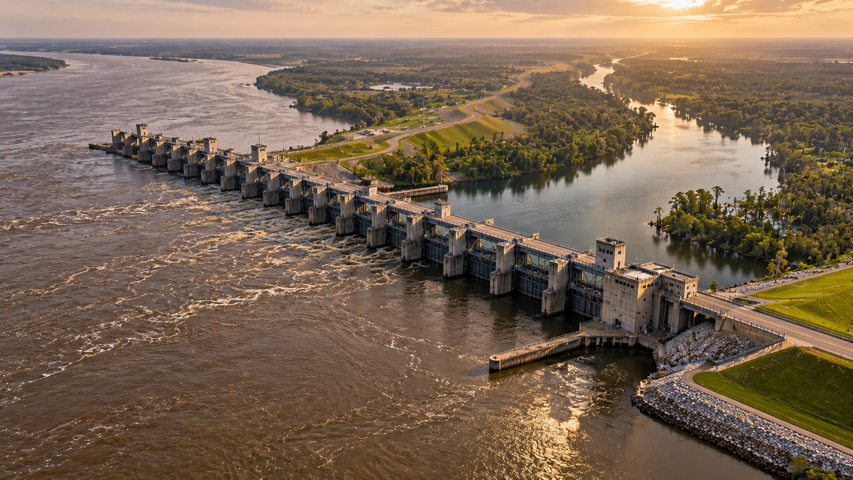
In central Louisiana, a set of Army Corps floodgates holds the Mississippi River in place. Without it, the river could jump to the Atchafalaya for good.
Every claim sourced
23 claims · 23 sources
0 disagreements logged
1 editorial correction
Last checked Oct 2, 2026
The story
The numbered claim log below connects facts in this story to their sources.
Rivers don't stay in one place. Over thousands of years, the Mississippi has shifted its course across Louisiana again and again, abandoning old channels for shorter, steeper routes to the Gulf of Mexico. Geologists call it avulsion, and it's how the river built most of southern Louisiana in the first place. In the 1800s, the Mississippi began setting up its next move. In 1831, a cutoff was dug across a big loop in the river called Turnbull's Bend to shorten the trip for steamboats. What was left of the loop, a channel that became known as Old River, ended up connecting the Mississippi to the Red River and the Atchafalaya River. The Atchafalaya offered the Mississippi a path to the Gulf much shorter than its own channel past Baton Rouge and New Orleans. And the river started taking it. Between 1850 and 1950, the share of flow going down the Atchafalaya climbed from under 10 percent to about 30 percent. Every year the Atchafalaya got bigger, and every year it pulled harder. By the early 1950s, the Army Corps of Engineers concluded that if nothing was done, the Mississippi could switch its main channel to the Atchafalaya by about 1990. That would leave Baton Rouge, New Orleans and the chain of ports and industry between them on a dwindling channel, while the full force of the river poured down the Atchafalaya Basin. So Congress stepped in. On September 3, 1954, it authorized the Old River Control Project. Construction began in 1955 and was completed in 1963, at a cost of about $67 million. The structures were designed to hold the river in place by freezing its natural 1950 flow split: about 70 percent of the combined flow of the Mississippi and Red Rivers stays in the Mississippi, and about 30 percent goes down the Atchafalaya. The split is measured as an annual average, and it's still set by law. In the spring of 1973, the system nearly failed. Floodwaters scoured the riverbed around the main structure, the Low Sill, and undermined its foundation. The Corps opened the Morganza Spillway downstream to take pressure off, and the structure held. But the damage was permanent. The Corps spent years repairing it, and in December 1986 it completed a second, backup structure, the Auxiliary Control Structure, at a cost of $206 million. In 1990, a privately built hydroelectric plant joined the complex. In 2011, a historic flood pushed 706,000 cubic feet of water per second through the complex, and the Morganza Spillway was opened for only the second time in its history. The control system held. Every day, these gates decide where America's largest river goes. As long as they hold, the Mississippi stays on the course it's followed for generations.
Last corrected: Oct 3, 2026.
Grew up near here?
Get the free Louisiana guide: every Hidden Current place in the region, with what you can still see and how to get there.
State guides are coming soon. Email signup is not available yet.
Watch the short documentary
Old River Control: The Floodgates Holding the Mississippi in Place, Louisiana
Claim log
| # | Claim | Sources | Status |
|---|---|---|---|
| 1 | The Three Rivers Confluence marker is at 31.0094, -91.6458 |
| Sourced |
| 2 | Old River Lock is at 31.0037, -91.6733 |
| Sourced |
| 3 | The complex is at river mile 315 in Concordia Parish |
| Sourced |
| 4 | The site is 50 miles northwest of Baton Rouge |
| Sourced |
| 5 | The river shifts course by avulsion; the Atchafalaya share rose from under 10% in 1850 to about 30% in 1950; the structure was completed in 1963 and nearly failed in 1973 |
| Sourced |
| 6 | The Corps concluded the river could change course by 1990 |
| Sourced |
| 7 | The Corps concluded the river could change course by 1990 |
| Sourced |
| 8 | A cutoff across Turnbull's Bend created Old River |
| Sourced |
| 9 | The project was authorized September 3, 1954, and construction began in 1955 |
| Sourced |
| 10 | The project cost $67M |
| Sourced |
| 11 | The project cost $67M |
| Sourced |
| 12 | The structure holds a 70/30 split based on 1950 proportions |
| Sourced |
| 13 | The split is measured as an annual average |
| Sourced |
| 14 | In 1973 floodwaters undermined the Low Sill, and Morganza was opened for relief |
| Sourced |
| 15 | The 1973 damage was permanent |
| Sourced |
| 16 | The 1973 damage was permanent |
| Sourced |
| 17 | Repairs were completed in 1981 |
| Sourced |
| 18 | The Auxiliary Structure was completed December 1986 at $206M |
| Sourced |
| 19 | The hydroelectric plant opened in 1990 |
| Sourced |
| 20 | In 2011 the complex passed 706,000 cfs, and Morganza opened for the second time |
| Sourced |
| 21 | Baton Rouge and New Orleans ports depend on the river staying in its channel |
| Sourced |
| 22 | The structures are visible from LA-15 |
| Sourced |
| 23 | Some markers flood at high water |
| Sourced |
Disagreements logged
No approved disagreements are logged on this page yet.
Submit a disagreement
Disagree with a fact in this story? Submit a source-backed note for editorial review. It stays private until approved and does not automatically become a correction.
Sources
- HMDB
- Recreation.gov
- Wikimedia Commons
- Wikipedia
- Wikiwand
- U.S. Army Corps of Engineers brochure
- Louisiana Department of Wildlife and Fisheries
- U.S. Army Corps of Engineers
- Atchafalaya Heritage Trail
- m.ammoth.us
- lacoast.gov
- KATC
Corrections
| # | Correction | Sources |
|---|---|---|
| 1 | The commonly circulated coordinates for the Old River Control Structure come from an aerial photo, not a surveyed point on the structure |
|