
Isolated Placeswwiigreenlandhistory
Bluie East Two: The WWII Air Base Abandoned in Greenland
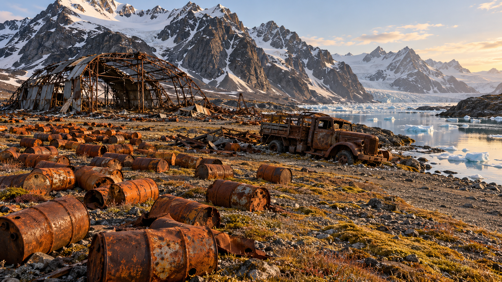
In 1942 the U.S. built Bluie East Two on a remote East Greenland fjord. Abandoned in 1947, it left a ruined hangar, trucks and fields of rusting drums.
Every claim sourced
30 claims · 30 sources
0 disagreements logged
7 editorial corrections
Last checked Oct 6, 2026
The story
The numbered claim log below connects facts in this story to their sources.
In 1940, Germany occupied Denmark, and the U.S. stepped in to take responsibility for the defense of Greenland, Denmark's vast Arctic territory. Greenland sat on the shortest air route between North America and Europe. In 1941, the U.S. began planning a string of bases there, code-named "Bluie," the wartime code name for Greenland. Bases on the west coast were called Bluie West, and those on the east coast Bluie East. Finding a site on Greenland's rugged east coast was hard. In November 1941, a U.S. Navy expedition led by Lieutenant Frederick Crockett used dog teams to search the area around Angmagssalik, now Tasiilaq. Near a place called Ikateq, meaning "shallow water," Crockett found a flat alluvial shelf at the base of high mountains, facing a narrow strait. It was the best site available, though it was subject to extreme weather. On July 26, 1942, a supply flotilla led by the Coast Guard cutter Comanche brought construction crews to build the base. By November 1, the station was sending weather reports, and in 1943 a 5,000-foot gravel runway was completed. Bluie East Two never became the trans-Atlantic stopover it was meant to be. Iceland's Keflavík proved more useful. But it served well as an alternate airfield, a weather and navigation station, and a base for search-and-rescue missions. After the war, the base lost its purpose, and at the end of 1947 the U.S. evacuated it along with many other stations in Greenland. The agreement that allowed the bases also allowed the U.S. to dispose of equipment and facilities in Greenland after consulting Danish authorities. So the Americans left almost everything behind. The Danish government had no use for the site, and local people took what they could use. The runway remained useful for occasional flights, including supplying construction of a Cold War radar station at Kulusuk in 1958. What stayed was the debris: a crumpled steel hangar, rusted trucks and vehicles, building materials, and thousands of fuel drums. Locals came to call the rusting orange barrels "American flowers." Over the years, as the drums rusted, leaded fuel leaked into the surrounding ground and channel. Bluie East Two is one of more than 30 abandoned U.S. military sites in Greenland from World War II and the Cold War. In January 2018, Denmark agreed to fund a cleanup of some of them, committing 180 million kroner over six years. Cleanup work at Bluie East Two began in late summer 2019. A 2023 study used drones and satellite imagery to document the base's rehabilitation. Some locals had argued the ruins should stay as they were, a historic site and a draw for visitors. However much is cleared, the shelf at Ikateq will still mark the place where the U.S. built an air base in the Arctic and then walked away from it.
Last corrected: Oct 6, 2026.
Grew up near here?
Get the free state guide: every Hidden Current place in the region, with what you can still see and how to get there.
State guides are coming soon. Email signup is not available yet.
Watch the short documentary
Bluie East Two: The WWII Air Base Abandoned in Greenland
Claim log
| # | Claim | Sources | Status |
|---|---|---|---|
| 1 | The Bluie East Two site was about 57 kilometers (31 nautical miles) northeast of Tasiilaq at 65°56′50″N 36°39′50″W, and was subject to extreme weather |
| Sourced |
| 2 | Bluie East Two's infobox coordinates are 65°56′29″N 36°40′30″W |
| Sourced |
| 3 | Bluie East Two is at 65.945278, -36.662500, about 57 kilometers northeast of Angmagssalik (now Tasiilaq) |
| Sourced |
| 4 | Bluie East Two is listed at 65.937183, -36.817065 |
| Sourced |
| 5 | Bluie East Two was a minor United States Army Air Forces airfield at Ikateq in eastern Greenland, operational from 1942 to 1947 |
| Sourced |
| 6 | Ikateq means "shallow water"; "Bluie West" and "Bluie East" were wartime code-names for two strings of planned radio stations in Greenland |
| Sourced |
| 7 | "Bluie" was the military code name for Greenland during the war |
| Sourced |
| 8 | The United States took responsibility for Greenland's defence in 1941 after Denmark was taken over by German forces |
| Sourced |
| 9 | In November 1941, Crockett used dog teams to reconnoitre the area around Angmagssalik and found an alluvial shelf at the base of high mountains facing a narrow strait near Ikateq |
| Sourced |
| 10 | The US Navy expedition under Lieutenant (jg) Frederick Crockett completed its evaluation at Ikateq on 15 Nov 1941 |
| Sourced |
| 11 | On 26 July 1942, the USCGC Comanche led a supply flotilla bringing construction crews; on 1 November the station began reporting weather; the 5,000-foot runway was completed in 1943 |
| Sourced |
| 12 | Bluie East Two never attained the prominence in trans-Atlantic air traffic originally intended, but served as an alternate airfield, for meteorology and navigation, and for search-and-rescue |
| Sourced |
| 13 | Keflavik in Iceland remained a more prominent area for US forces in this part of the Atlantic |
| Sourced |
| 14 | The field was evacuated at the end of 1947; the Danish government had no interest in the facility, and usable items were appropriated by visiting locals |
| Sourced |
| 15 | The strip served in a supply role for construction of the early warning radar station DYE-4 at Kulusuk in 1958 |
| Sourced |
| 16 | Bluie East Two should not be confused with the abandoned settlement of Ikkatteq, southwest of Angmagssalik |
| Sourced |
| 17 | Ikkatteq was a village on an island in Sermilik Fjord about 16 km west of Tasiilaq, abandoned in 2005 |
| Sourced |
| 18 | Article 11 of the original agreement states that equipment and facilities may be disposed of in Greenland by the United States after consultation with Danish authorities |
| Sourced |
| 19 | The base was abandoned in 1947 with everything left behind, including over 10,000 fuel barrels of leaded fuel |
| Sourced |
| 20 | Locals call the rusted barrels "American flowers" |
| Sourced |
| 21 | Bluie East Two is one of more than 30 abandoned U.S. military bases in Greenland from World War II or the Cold War |
| Sourced |
| 22 | On January 11, 2018, Denmark announced it would contribute 180 million kroner ($29 million U.S.) over six years to begin cleaning up abandoned military bases on Greenland |
| Sourced |
| 23 | Cleanup work at Bluie East Two began in late summer 2019 |
| Sourced |
| 24 | It is estimated around 200,000 oil drums are at the site |
| Sourced |
| 25 | The base was left with dozens of vehicles, a crumpled air hangar, and over 20,000 oil barrels |
| Sourced |
| 26 | As the drums rusted, fuel leaked into the Ikateq channel and surrounding fjords |
| Sourced |
| 27 | A 2023 survey used photogrammetric and remote sensing methods to document the rehabilitation of Bluie East Two |
| Sourced |
| 28 | The site is about an hour-and-a-half flight from Keflavik, Iceland, followed by two boat rides |
| Sourced |
| 29 | Many locals prefer the site to remain as it is, as a tourist draw |
| Sourced |
| 30 | Visitors to the site in 2017 encountered fuel drums and asbestos-laden building materials |
| Sourced |
Disagreements logged
No approved disagreements are logged on this page yet.
Submit a disagreement
Disagree with a fact in this story? Submit a source-backed note for editorial review. It stays private until approved and does not automatically become a correction.
Sources
- Wikipedia
- ww2db.com
- Atlas Obscura
- worldabandoned.com
- iceland-photo-tours.com
- olihar.com
- National Geographic
- hecktictravels.com
- flickr.com
- MDPI Remote Sensing
- guidetogreenland.com
Corrections
| # | Correction | Sources |
|---|---|---|
| 1 | "One of the most isolated military outposts in the North Atlantic" is an unverified superlative; sources describe the site as subject to extreme weather |
|
| 2 | Bluie East Two is about 57 km northeast of Tasiilaq, not about 13 km as some sites state |
|
| 3 | Bluie East Two at Ikateq is not the same place as Ikkatteq, a separate village west of Tasiilaq abandoned in 2005 |
|
| 4 | Estimates of drums at the site vary widely: over 10,000, over 20,000, or about 200,000 |
|
| 5 | Estimates of drums at the site vary widely: over 10,000, over 20,000, or about 200,000 |
|
| 6 | Bluie East Two was operational from 1942 to 1947; one source dates its establishment to 1941, when the site was surveyed |
|
| 7 | One listing places Bluie East Two at 65.937183, -36.817065, roughly 7 km west of the coordinates given by other sources |
|
More Isolated Places places
- The Island Almost Nobody Can Reach
- Supai, Arizona: The Village With No Road Where Mail Comes by Mule
- Kiruna, Sweden: The Arctic City Moving to Escape Its Own Mine
- Whittier, Alaska: The Town That Lives in One Building
- Point Roberts: The U.S. Town You Reach by Driving Through Canada
- Kentucky Bend: The Kentucky Exclave You Reach Through Tennessee